

Castlecrag Mountain: Attempt #1 (The Coldest, Wettest, Muddiest Hike Yet)

Updated: 1 day ago

(August 2026)
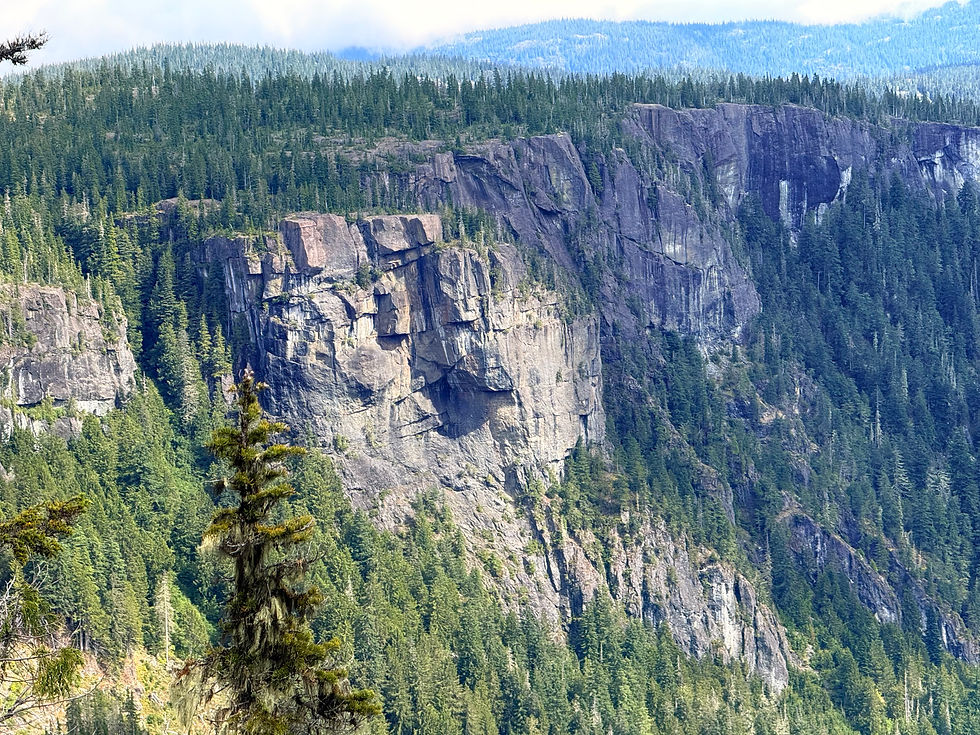
My search for a moderate alpine scrambling objective got me interested in a small peak in the Forbidden Plateau region of Strathcona, Castlecrag Mountain. At 1,765 m, it's not particularly tall, but its main appeal lies in its iconic castle-like profile, which looks like a very epic objective when approched from Paradise Meadows. The dramatic near-vertical north aspect, which drops steeply to the shore of Moat Lake, has no documented records of ascents, but the south side is relatively easy to access.
Unlike many Island mountains, which involve miserable logging roads and hours of bushwhacking for a few pitches of choss, Castlecrag's challenge lies in distance, not difficulty. It is best known as part of the Moat Lake circuit, an epic 20km loop connecting Mt Albert Edward, Mt Frink, and Castlecrag via an alpine ridge network. Hiking Castlecrag alone is a good way to explore the subalpine terrain of Forbidden Plateau while escaping the crowds piling up on Albert Edward - the most popular, and photogenic, summit of the area.
Scroll down to hear about...
Overview (Trip Rating)
Trail Description:

Trip Rating: 3.5/5 STARS
While I did not get to stand on the summit of Castlecrag this year, next summer might be the one... only time will tell. As somebody who has already hiked Mt Albert Edward at 11, plus numerous other multi-day adventures in the island subalpine, I was looking for a bridge between conventional backpacking to off-trail navigation on unmarked alpine terrain. As a climber with solid multipitch experience, this connection is not hard to make, and Castlecrag tests both scrambling, route-finding, and endurance in one go.
I would not say this hike is particularly hard, because hiking from trailhead to 'basecamp' is a steady plod along an even 9km, popular among dayhikers and families with kids. Past Circlet Lake, the trail becomes narrower, but still easy to navigate due to the abundance of cairns and visibility. I cannot speak for the push past Moat Lake, the boulder field, and the supposedly 'short fun summit block scramble,' because weather didn't allow us to reach the crux of the trip.
Forbidden Plateau is best known for Mt. Albert Edward, the island's 6th-tallest mountain, summited by a steep 5.9 km to a photogenic final ridge. This trail piles with crowds on clear days and gets increasingly dangerous in whiteout. Read my 2024 Albert Edward trip review HERE (link valid when blue).
Easy linkups around Kwai and Circlet Lakes make for great introductory multi-day hikes, while the 20+ km traverse to Wood Mountain Parking Lot is less-known and crosses the core of the plateau. The ultimate objective in the area is the off-trail, point-to-point Augerpoint Traverse, which links Albert Edward with Ruth Masters Lake and Jack's Trail down to Buttle Lake. Parties completing this traverse are highly advised to be confident in GPS navigation and informal camping. Some sections of this traverse are told to be easier with a rope.

Getting There:
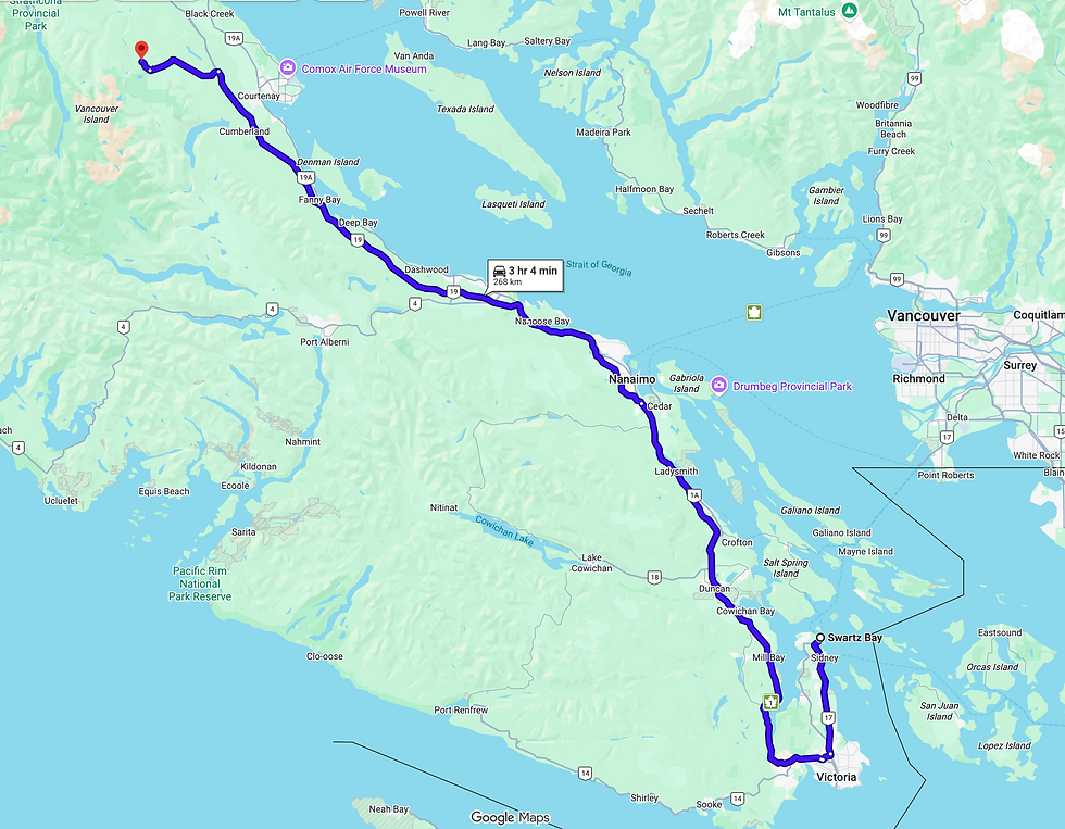
From Victoria, follow Trans - Canada Hwy/BC-1 N and BC-19 N to Nanaimo, then merge onto BC-19 North (Inland Island Hwy) to Courtenay. Take the exit for Dove Creek Rd /Strathcona Parkway, then follow signs upwards toward Mount Washington. At the ski resort, turn left off Strathcona Parkway onto Nordic Road to Raven Lodge. Some cars require chains on this section of the road in winter snow conditions (October through March/April).
Nearby Accommodation Options:
Comox Valley: The vibrant valley hosts three cities (Courtenay, Comox, and Cumberland) all which offer many Airbnb's, hotels, motels, and more. The Comox Valley is about 1hr to 30 mins away from the trailhead.
Mt Washington Ski Resort: Dominated by mountain bikers and hikers in summertime, the ski resort village is conveniently 5 mins from the trailhead. The number of hotels and lodges grows every year, but know that almost all restaurants are specifically ski-oriented and will be closed for summer. Be aware that there is no grocery store or gas station on the mountain, the nearest would be ~30 mins driving to Courtenay.

Backcountry Camping Fees:
For this hike, standard Strathcona Provincial Park Backcountry Camping fees apply during the summer months (June 15 - September 30). This information is current as of August 2026:
16+ years old: $10
6-15 years old: $5
Under 6: No fee
Learn more about Strathcona Provincial Park's regulations at https://bcparks.ca/strathcona-park/#camping
While camping, please follow standard Leave No Trace principles and use all available food caches (or suspend food from trees, if needed). On this hike there are urine-diversion outhouses located at the trailhead, Lake Helen Mackenzie, and Circlet Lake. Kwai, Croteau, and Battleship Lakes also have campsites/group sites with bear caches and toilets, but they are not on the immediate trail to Castlecrag and would require a long unnecessary detour. Should you need to improvise a camping bathroom, please stay away from drinking water sources and head at least 50m upslope.

Trail Description:
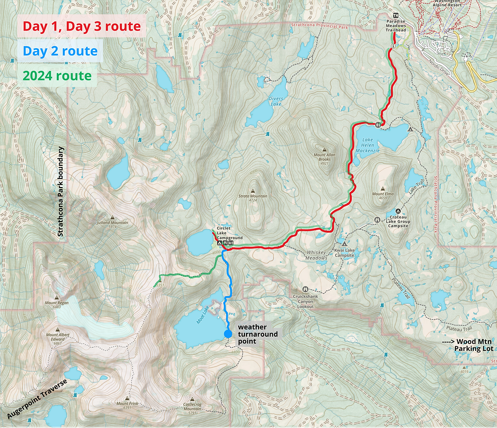
Paradise Meadows Official Trailhead (Raven Lodge)
0 - 3 km: Well-graded gravel paths and boardwalks, part of the Centennial Circuit
3.0 km: Lake Helen Mackenize
3 - 6 km: Circle west around Lake Helen Mackenzie and over the saddle between Mt Allan Brooks and Mt Elma to the Ranger Cabin. Steep switchbacks.
6 km: Forbidden Plateau Ranger Cabin and the junction to Kwai, Croteau, and Battleship Lakes
6 - ~10 km: Steady elevation gain along a rooty trail through subalpine meadows to Circlet Lake. Several up-and-downs!
~10 km: Duck Pond and Circlet Lake (first-come, first-serve)
10.5 - 11.5 km: Take left at Albert Edward/Moat Lake junction and along a narrow cairn-marked trail to Moat Lake.
...obscure fog and rapidly-shifting clouds made this our turnaround point...
12 - 13.5 km: Stay left of Castlecrag along unmarked trails on subalpine plateau.
13.5 km: Castlecrag boulder field (steep talus field to be crossed)
~15+ km: Unmarked scramble along the south side to a summit block. The Castlecrag Mountain summit is marked by a summit register box.
Mt Frink/Albert Edward ridge junction: Bypass the right turn to the summit scramble and continue along to reach Mt Frink for the continuation of the Moat Lake Circuit.


DAY 1:
Trailhead - Lake Helen Mackenzie - Ranger Cabin - Circlet Lake
~10 km
We weren't too worried to start out early, because the day was looking to be cold and foggy and we wanted that relaxed morning. At about ~9:30 am we drove up to Raven Lodge, filled out the camping form, and set off on the flat paths of winter nordic ski routes.
The first part of the trail was fairly uneventful, although it was interesting to remember everything after 2 years... strange how my memory from 2024 blanked out on a lot of the trail. By 10:30 we reached the trail access to Lake Helen Mackenzie. Head right for the campsite, Kwai Lake, and etc, and left for the Mt Allan Brooks/Mt Elma saddle.

We were to be heading straight into the thickest clouds to the left of the hill in the photo. I was hoping they'd clear up, but no luck.


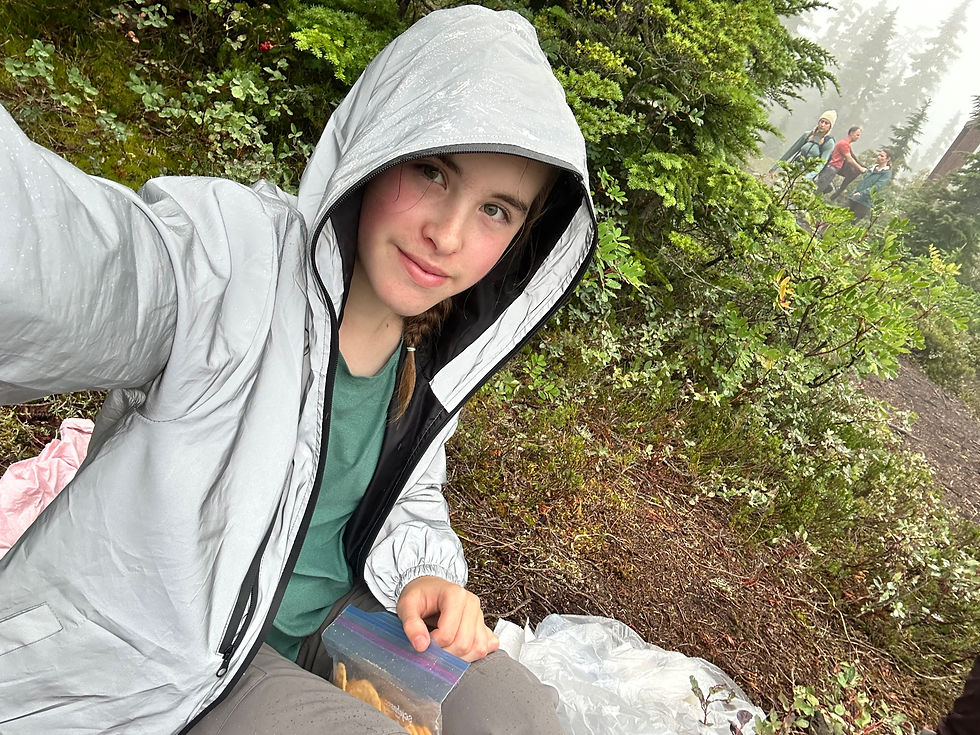


Recreating the same photo from 2 years ago! Left: 2024, age 11/12. First backpacking trip ever! Right: 2026...

At around 6 pm it began to rain, so we made some dinner (noodles!) and got in the tent as quick as possible. By then, it was almost obvious we weren't getting to the summit of a pile of wet rocks tomorrow. The scramble itself wasn't so much of a concern as the descent; navigating a wet talus field does not sound like fun.
DAY 2:
Circlet Lake - Junction - Moat Lake - Castlecrag Mountain weather turnaround point
~8 km
The following morning started out bright! I was excited to see some clear skies and almost got my hopes up again.


I was glad to have brought my 24L alpine pack, which I typically use for multipitch climbing adventures, because that allowed me to leave this big bulky Gregory Jade 63L to dry in the sun.

Photo above shows the first set of tent pads you see upon arrival, they are convenient if you don't mind the slightly-stagnant water source and want to cut down the extra ~1km around Circlet Lake. I was voting to camp here - after all, it is nice to see your tent right away after a long day - but Mom preferred the stream running along the far end of Circlet Lake. Hence, we walked extra 🤣.
Another important lesson learned on this trip was to always wear waterproof pants, even if it isn't actively raining. A narrow trail lined with overhanging heather all the way to Moat Lake soaked my pants completely and in the end I had to wear shorts... in really cold weather. 😭

Along this trail, there are many picturesque wooden signs that sometimes show the correct path, and sometimes... don't. A close eye will notice the date carved on a few of them - as far as the early 1900s. Trails and junctions were obviously different back then, so do not trust them!

This part of the trail (image above) would be dangerous in white-out, so we took the time to build as many cairns as possible and mark flagging tape wherever we could. Not gonna lie, I was on the verge of making the bail-out call, because visibility was drastically dropping and we couldn't see five metres ahead. This part of the trail would've offered spectacular views on Mt Frink to the right and Castlecrag in the distance straight ahead.

This was my first time hiking in a rocky subalpine environment in cloudy conditions, and it was amazing to see how rapidly those clouds moved. I am always keen on practicing important mountaineering skills - like easy scrambling, route-finding on unmarked terrain, and white-out conditions - to better prepare myself for bigger objectives in the future.


There were so many false paths along this trail. Because it's a less-travelled route than the famous Albert Edward variation (Moat Lake Circuit, counter-clockwise), there are SO MANY junctions and veer-offs and faint boot-beaten paths. Gaia GPS was very helpful, unlike the trail to Cream Lake 😂 (Read about our subalpine adventures around the Septimus-Rosseau region HERE).


Reached the southern end of Moat Lake Moat Lake by about 1 pm. All the photos below are looking directly at the Frink/Castlecrag col in the clouds.


This was my first time testing my Ortovox Trad Zero 24L in the backcountry, and I loved it. The lightweight design made it easy to carry just the essentials, plus I was able to access my phone without stopping with a handy side pocket. This pack will make it to the summit with me next time, 100%! Here is is holding up great even after being thrown around in wet moss... Click HERE to read a a blog post reviewing this pack's technical features, including some more October alpine adventures! (Link valid when blue).




DAY 3:
Circlet Lake - Lake Helen Mackenize - Trailhead
~10 km
While I was disappointed to leave without the summit, I was happy to have gotten another weekend in the backcountry before school started again. I usually hike for experience, e.g. steep scrambles for route-finding, long pushes for endurance, etc., and not for the summit tick-off. Castlecrag will wait until next summer 😄 (Stay tuned for blog post coming up summer 2027!!!)


Thank you so much for reading my post and making it to end! It means a lot to know someone took the time to read this!
✉️ Email sophia.roukhlova@gmail.com for any questions, inquiries, or collabs!
👇 Drop a comment below to tell me what you think!
🙏❤️ I always appreciate hearing your feedback
Enjoy your hike!
-- Sophia


Stay tuned for Castlecrag Mountain Attempt #2, coming summer 2027!
Other posts coming soon 👀: Mt Cokely (Mt Arrowsmith) Trip Review